HISTORY OF PALIN
It was on October 16, 1836 that Palín, acquired the category of municipality, it is believed that the municipality had been created before, but no official data has been found. The independent district changed its name and category to department by Executive Agreement of 8 of May of 1886, taking the name of Amatitlán. Then the department of Amatitlán was suppressed by legislative law number 2,081 of April 29, 1935 with the publication and enforcement of the executive on May 2 of that year, and based on the same decree, the municipality of Palín became part of the Jurisdiction of the department of Escuintla. To which it currently belongs.
Etymologically, Palin comes from the voices of Palaq (Standing) and Ha (Water), which together mean standing water (standing) in view of the fact that the population is in the foothills of the Agua volcano. In the Nahuatl language, pronounced by the natives Pedro de Alvarado brought when he invaded Guatemala, they called these lands PALIN. Word that is composed by the voices PALI (Extenso) and voice IN (movement, agitation, wind). Uniting these two concepts we can say that the name of Palin is translated to: PA "LAQHA: Which means at the foot of the volcano of water and PALIN: Which means Place of the winds.


CULTURE AND IDENTITY
Identity can not be seen as fixed and unalterable, if not as a self-defining cultural dimension that remains and is constantly updated in social relations. In the municipality of Palín, the expression of culture is crossed by many social and territorial variables.
Historically, ethnic origin has marked a differentiation, but it has also given rise to forms of cultural syncretism. In the municipality group ladino is the predominant one, followed by the ethnic group poqomam, which territorially speaking has been located in the urban zone what in economic and social terms it allows the development of the municipality.
It can be evidenced in the manifestation of the main cultural activities and traditions in the municipality and not so much in space of decision making in the municipality, this is a factor of exclusion that still persists since the colonization of the towns, therefore, it is It is important to promote programs that guarantee greater participation of the citizens in the political and social decisions of the municipality, since the development contribution will be indispensable.

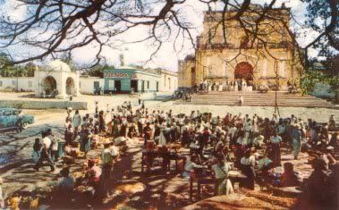
MAIN CELEBRETIONS
Many of the cultural expressions of the municipality are part of the activities commemorating the founding of the neighborhoods of the municipality, which have a strong territorial and religious connotation, since most are related to Catholic santorian representations, identifying that the Poqomam population also has some own expressions, it is possible to recognize the strong syncretism existing in the cultural and spiritual manifestations of the poqomam population.
The patronage fair of the municipality of Palín is celebrated on July 30, in honor of San Cristóbal, also each neighborhood has a pattern to which they celebrate on specific dates, among which we can mention the following:
Barrio San José: March 19th. In honor of San Jose, there are serenades celebrations at 4 am, religious activities in the church, processions in the streets and in the afternoon parties, dances, piñatas, pyrotechnic games, with lunches for the inhabitants of the neighborhood and special guests .
Barrio San Antonio: June 13. In honor of San Antonio, religious activities take place in the church. On leaving the Mass, the neighborhood confraternity gives the attendants the bread they are sent to do especially for this day, then processions through the streets accompanied by the Baile de los Fieros, Band music and drums, afternoons parties, dances, piñatas, pyrotechnic games, with lunches for the inhabitants of the neighborhood and special guests.
San Pedro neighborhood: June 29. In honor of San Pedro, activities are held from the 28th, with a presentation of pure marimba music on the main street of the neighborhood, on the 29th they celebrate serenades at 4am, religious activities in the church, processions In the streets and in the evenings parties, dances, piñatas, pyrotechnic games, with lunches for the inhabitants of the neighborhood and special guests, which are also held the following day.
Barrio San Lucas: October 18th. In honor of St. Luke, the Activities begin with a novena in honor of the patron, then the 18 serenades at 4 am, religious activities in the church, processions through the streets where theater plays are performed biblical and cultural passages , Also known as loas; Also parties, dances, piñatas, pyrotechnic games, with lunches for the inhabitants of the neighborhood and special guests, Colonia San Martín: November 3, celebrations in honor of San Martín de Porres. Colonia Palinché: December 26, celebrations in honor of St. Stephen.

LIMITS
The municipality of Palín is located in the north-eastern part of the department of Escuintla, in Region V or Central Region. It is located in the north latitude 14 ° 24'14 "and in the West longitude 90 ° 41'55". It limits to the North with the municipality of Amatitlán, to the South and to the East with San Vicente Pacaya and to the West with the municipality of Escuintla.
It has a territorial extension of 88 km2 and is located at a height of 1,145 msnm, reason why its climate is generally temperate and sometimes cold by the wind currents that circulate through the call cannon of Palín. It is located at a distance of 40 km from the capital city and 17 km from the departmental head of Escuintla.
The municipality of Palín is divided territorially as follows: the municipal head, 2 villages, 3 farmhouses, 38 farms, 42 colonies and 9 settlements on the railway line.
In terms of its hierarchy, the populated places of the municipality are divided of the following form:
Villages: La Periquera and San Pedro El Cerro.
Caseríos: San Raymundo, Monte Cristo and Monte Monte.
Colonies: Las Marías, San Francisco, Balcones II, San Martín, El Cortijo, Balcones I, Las Victorias, San Benito, Los Sauces, El Cielito, Villas of Palín, Palinché Annex, Model, Valparaiso, Villa Estelita, La Estación , El Mirador, Los Naranjales, Ilusiones, María Mattos, Los Almendros, Valle de las Flores, El Cortijo, Sacramento 1 and 2 and others in formation.
Neighborhoods: San Pedro (Zone 1), San Lucas (Zone 2), San Antonio (Zone 3) and San José (Zone 4).
Farms: Gravileas, Bugambilias, Easter, Chiriviscal, Bella Vista, María Isabel.
Fincas: San Fernando, San Francisco, El Rosario, Medio Monte, Carmela, La Positiva, La Piedad, La Canoa, Bedford, Raguay, San Jose Bella Vista, Villa Laura, Majulé, El Llano, El Farol, El Barretal, El Sacramento , Santa Rita, María Mattos.
